


There is carry-in access, and no one is allowed to operate a motorboat having more than 10 hp.
Adams Pond in South Bridgton is a quiet pond that provides an enjoyable paddling experience and the possibility of spotting loon, deer, moose, many birds, and other wildlife. Adams Pond was first monitored by LEA in 1988. It was added to our biweekly monitoring program that same year.
Click below for the most recent data summary.
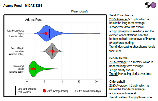
Adams Pond surface water chlorophyll (ppb), phosphorus (ppb), and Secchi depth (meters) data comparison. Colored areas represent the long-term range of values, from minimum to maximum. Area thickness indicates frequency of measurements at that value. Area thickness increases as more measurements are reported at that value. The vertical black line represents the long-term average value. The large red dot represents 2025’s average value. The small red dots represent individual readings taken in 2025.
Water Quality overview and methods
2025 as a Year (overall summary)
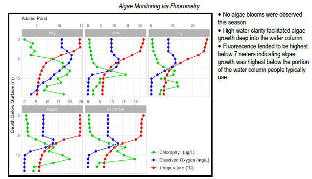
 Algae Monitoring Summary
Graphs have been included for each test site to visually compare fluorometer, temperature, and oxygen profiles from May through September. The vertical axis (y-axis) indicates depth below the surface, while the horizontal axis (x-axis) represents reported values. Three different parameters are being reported on the same graph, which results in the value units for the horizontal axis varying, based on parameter. Units are noted in parentheses in the legend.
LEA also has an active Courtesy Boat Inspection Program on Adams Pond and offers Technical Assistance to landowners through Clean Lake Check Ups.
The principal fisheries are brook trout, largemouth bass, smallmouth bass and white perch. Adams Pond was chemically reclaimed in September, 1955 to remove competing species and permit intensive management for brook trout. Illegal introductions of largemouth bass, smallmouth bass and white perch have occurred, resulting in intensive competition for the brook trout. Due to the lack of spawning habitat, Adams Pond is stocked annually with brook trout. A few trout in the two-pound range are taken every year.
General fishing laws apply, except: CI (Closed to ice fishing). ALO (Artificial lures only), S-10 (Closed to all fishing from December 1 – March 31), S-13 (No size or bag limit on bass). Motorboats over 10 horsepower prohibited. From October 1 – November 30: ALO (Artificial lures only), S-7 (All trout, landlocked salmon, and togue caught must be released alive at once).
Return to LEA’s Lake Look-Up page to search for a different lake, or type in below
