


A grist mill was built on Sucker Brook, the outlet of Beaver Pond, in the early 1800s. “Mill Privilege” (water rights) to the stream and pond were sold or handed down. Today, the stream has returned to a more natural state, and salmon sometimes swim up it in the winter months from neighboring Moose Pond. Evidence of prior forestry can be seen in some of the old logs that stick up to the surface.
LEA first monitored water quality on Beaver Pond in 1988. Shortly after, in 1990, it was added to our biweekly monitoring program.
Click below for the most recent data summary.
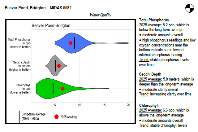
Beaver Pond surface water chlorophyll (ppb), phosphorus (ppb), and Secchi depth (meters) data comparison. Colored areas represent the long-term range of values, from minimum to maximum. Area thickness indicates frequency of measurements at that value. Area thickness increases as more measurements are reported at that value. The vertical black line represents the long-term average value. The large red dot represents 2025’s average value. The small red dots represent individual readings taken in 2025.
Water Quality overview and methods
2025 as a Year (overall summary)
LEA also has an active Courtesy Boat Inspection Program on Beaver Pond and offers Technical Assistance to landowners through Clean Lake Check Ups.
Beaver pond thermally stratifies during the summer, and the amount of cold, oxygenated water available for salmonid management is very limited. In addition, the presence of competing and predatory warmwater fish further reduces the potential for a coldwater fishery. Beaver Pond’s habitat is ideal for warmwater species, and largemouth bass, chain pickerel, and white perch all produce excellent angling opportunities.
General fishing laws apply. Motorboats with internal combustion engines are prohibited.
Return to LEA’s Lake Look-Up page to search for a different lake, or type it in below.
