


Known invasive species: variable-leaf milfoil
Brandy Pond acts as a highway between Long Lake and Sebago Lake. It can be accessed through public boat launches on either lake.
Brandy Pond was originally called the Bay of Naples and was a primary commercial and recreational travel route during Maine’s early development stages. LEA began monitoring Brandy Pond’s water quality in 1972. In 2003, LEA’s milfoil team discovered patches of milfoil. Since then, milfoil divers have worked hard to remove patches, while CBI’s work to prevent more milfoil from entering Brandy Pond.
Click below for the most recent data summary.
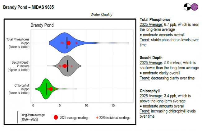
Brandy Pond surface water chlorophyll (ppb), phosphorus (ppb), and Secchi depth (meters) data comparison. Colored areas represent the long-term range of values, from minimum to maximum. Area thickness indicates frequency of measurements at that value. Area thickness increases as more measurements are reported at that value. The vertical black line represents the long-term average value. The large red dot represents 2025’s average value. The small red dots represent individual readings taken in 2025.
Water Quality overview and methods
2025 as a Year (summary for all lakes)
LEA also has active Courtesy Boat Inspection and LakeSmart programs on Brandy Pond and offers technical assistance to landowners through Clean Lake Check Ups.
Because Brandy Pond serves as a passageway between Sebago Lake and Long Lake, cold water fish species such as landlocked salmon, brook trout, and brown trout can all be found within its waters. In addition to these coldwater fish, Brandy also supports populations of smallmouth bass, largemouth bass, white perch, yellow perch, chain pickerel, hornpout, white sucker, smelts, minnows, cusk, and sunfish. Although Brandy Pond is not stocked, Sebago Lake and Long Lake are both regularly stocked with landlocked salmon.
A survey to document erosion problems within the Brandy Pond Watershed began in late April of 2009 and finished in early October. Through the survey, volunteers and technical staff identified 73 erosion sites within the watershed. Although most of the sites were considered to have a low or medium impact on the pond, the cumulative impact of all these areas is sizable. Erosion on residential property and private roads were the largest problems identified during the project.
Return to LEA’s Lake Look-Up page to search for a different lake, or type it in below.
