


Foster Pond was named after the Foster family, who set up saw and grist mills on the outlet in the early 1800s. The pond’s other name, Ingalls Pond, refers to another prominent family during Bridgton’s early history.
LEA first monitored Foster Pond’s water quality in 1984.
Click below for the most recent data summary.
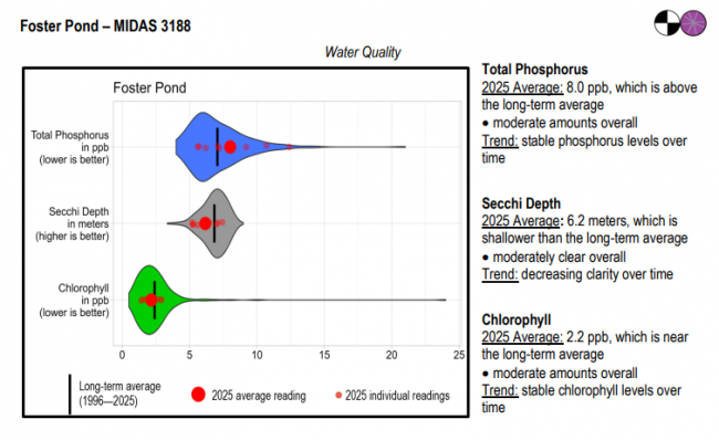
Foster Pond surface water chlorophyll (ppb), phosphorus (ppb), and Secchi depth (meters) data comparison. Colored areas represent the long-term range of values, from minimum to maximum. Area thickness indicates frequency of measurements at that value. Area thickness increases as more measurements are reported at that value. The vertical black line represents the long-term average value. The large red dot represents 2025’s average value. The small red dots represent individual readings taken in 2025.
Water Quality overview and methods
2025 as a Year (summary for all lakes)
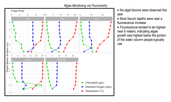
 Algae Monitoring Summary
Graphs have been included for each test site to visually compare fluorometer, temperature, and oxygen profiles from May through September. The vertical axis (y-axis) indicates depth below the surface, while the horizontal axis (x-axis) represents reported values. Three different parameters are being reported on the same graph, which results in the value units for the horizontal axis varying, based on parameter. Units are noted in parentheses in the legend.
LEA also offers technical assistance to landowners on Foster Pond through LakeSmart evaluations and Clean Lake Check Ups.
Foster Pond provides good habitat for species such as smallmouth bass, yellow perch, and chain pickerel. Although the pond is annually stocked with brook trout from state hatcheries, it is poorly suited for coldwater species as the entire water column becomes quite warm during the late summer. Foster Pond also has populations of hornpout, smelt, and fallfish.
General fishing laws apply. Motorboats over 10 horsepower are prohibited.
Return to LEA’s Lake Look-Up page to search for a different lake, or type it in below.
