


The shoreline of Island Pond is fringed with a few seasonal and year-round residents and is home to Fernwood Cove Summer Camp for Girls.
Island Pond drains to the Crooked River, which flows to Sebago Lake and provides drinking water for more than 200,000 people in southern Maine.
Click below for the most recent data summaries. For descriptions of each program, return to our Lake Look-Up page.
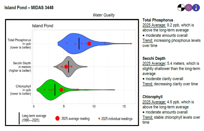
Island Pond surface water chlorophyll (ppb), phosphorus (ppb), and Secchi depth (meters) data comparison. Colored areas represent the long-term range of values, from minimum to maximum. Area thickness indicates frequency of measurements at that value. Area thickness increases as more measurements are reported at that value. The vertical black line represents the long-term average value. The large red dot represents 2025’s average value. The small red dots represent individual readings taken in 2025.
Water Quality overview and methods
2025 as a Year (summary for all lakes)
Temperature maps were generated using daily mean temperature values, which help determine temperature across depth and time. Temperature is represented by colored contours, where the red to blue color range corresponds to a high to low temperature range. The vertical bar on the right side of the temperature map indicates the temperature each color represents in degrees Fahrenheit (°F). The horizontal axis shows the months sensors were deployed, while the left-hand vertical axis shows sensor depth (meters) below the water’s surface.
Temperature stratification shows up as areas of the plot where colors change in the vertical direction and contour lines are tilted more towards horizontal (from June through early November). The area where temperature changes most rapidly with depth is often referred to as the thermocline. Vertical contour lines indicate mixed conditions, and areas of a single color from top to bottom (such as late-October into November) indicate completely mixed conditions. Warm, stratified conditions stand out as darker red areas. Large gaps between lines means there is a large temperature difference between depths.
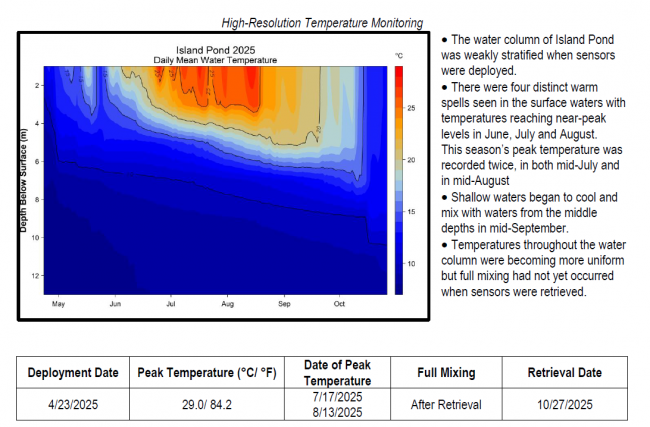
High Resolution Temperature Monitoring Methods and Reading Graphs
 Algae Monitoring Summary
2025 data coming soon
LEA also offers technical assistance to landowners through LakeSmart evaluations and Clean Lake Check Ups.
Island Pond provides good habitat for warmwater fish species, but it also has a considerable area suitable as trout habitat. Although there are abundant populations of bass, pickerel, and other warmwater competitors, management for trout is still possible. A cool, well-oxygenated layer of water provides refuge for the trout during the summer, and an abundant smelt population provides them with a good forage base. Annual stocking with trout is necessary to maintain the fishery because natural reproduction is very limited.
General fishing laws apply, except: S-13 (No size or bag limit on bass).
In the spring of 2007, LEA worked with the Island Pond Association and Fiddlehead Consulting to conduct a survey of erosion sites within the pond’s 1243 acre watershed. As part of the project, volunteers and technical staff identified 47 erosion sites that have a negative impact on the pond. Most of the sites documented were on town roads and residential properties. The report includes a brief description, location information, and recommendations on how to correct each problem. In addition to documenting erosion, the project served as an educational tool for citizens to learn about water quality and how our activities affect ponds and lakes.
Return to LEA’s Lake Look-Up page to search for a different lake, or type it in below.
