


Little Moose Pond in Waterford has quiet coves and rocky ledges that provide a variety of different habitats for waterfowl and wildlife viewing. It’s a great place to paddle along a pristine shore. There are very few camps and residential dwellings.
Click below for the most recent data summary.
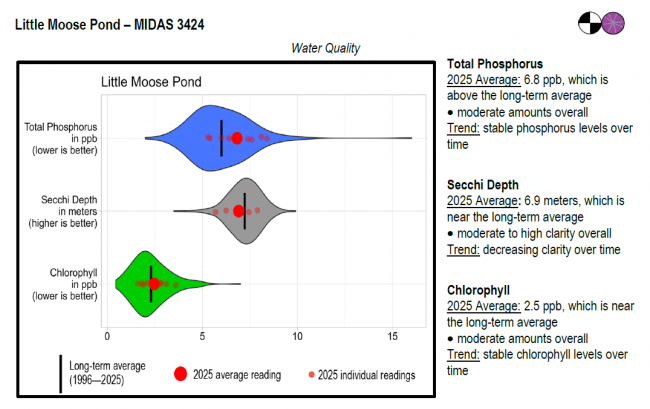
Little Moose Pond surface water chlorophyll (ppb), phosphorus (ppb), and Secchi depth (meters) data comparison. Colored areas represent the long-term range of values, from minimum to maximum. Area thickness indicates frequency of measurements at that value. Area thickness increases as more measurements are reported at that value. The vertical black line represents the long-term average value. The large red dot represents 2025’s average value. The small red dots represent individual readings taken in 2025.
Water Quality overview and methods
2025 as a Year (summary for all lakes)
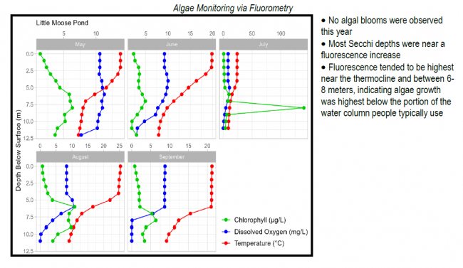
 Algae Monitoring Summary
Graphs have been included for each test site to visually compare fluorometer, temperature, and oxygen profiles from May through September. The vertical axis (y-axis) indicates depth below the surface, while the horizontal axis (x-axis) represents reported values. Three different parameters are being reported on the same graph, which results in the value units for the horizontal axis varying, based on parameter. Units are noted in parentheses in the legend.
LEA also offers technical assistance to landowners through LakeSmart evaluations and Clean Lake Check Ups.
Water transparency is excellent, and general water quality is suitable for both warmwater and coldwater fish. The pond thermally stratifies during the summer months, but areas below 25 to 30 feet are deficient in oxygen. Despite this limitation, there is suitable water quality to support a coldwater fishery. Interspecific competition and predation by warmwater fish significantly compromise efforts to manage for brook trout. Brook trout fisheries are sustained through an annual maintenance stocking program. Abundant white perch are above average in size and quality and are commonly caught between 9 and 14 inches long. Largemouth bass were established as a result of an unauthorized introduction.
General fishing laws apply. Motorboats over 6 horsepower are prohibited.
Return to LEA’s Lake Look-Up page to search for a different lake, or type it in below.
