


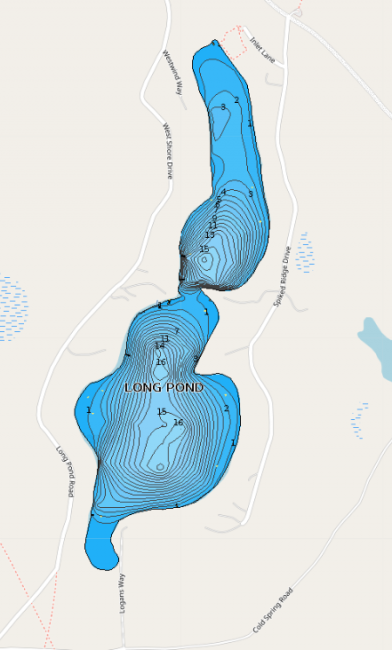
Carry-in access is available through a town lot located on the southern shore of Long Pond.
Long Pond is a small, spring-fed pond in Denmark. It is located between the larger Pleasant Pond and tiny Beaver Pond. It is monitored by LEA staff once a year in August.
Click below for the most recent data summary.
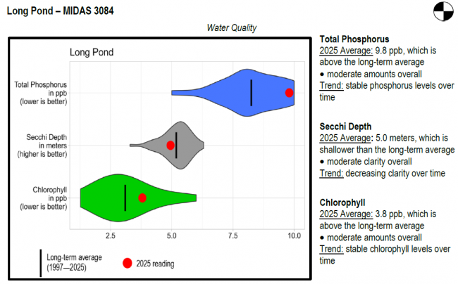
Long Pond surface water chlorophyll (ppb), phosphorus (ppb), and Secchi depth (meters) data comparison. Colored areas represent the long-term range of values, from minimum to maximum. Area thickness indicates frequency of measurements at that value. Area thickness increases as more measurements are reported at that value. The vertical black line represents the long-term average value. The large red dot represents 2025’s average value. The small red dots represent individual readings taken in 2025.
Water Quality overview and methods
2025 as a Year (summary for all lakes)
LEA also offers technical assistance to landowners through LakeSmart evaluations and Clean Lake Check Ups.
Long Pond was chemically reclaimed in September 1958, to remove competing species and permit more intensive management for brook trout. The successful reclamation along with a brook trout stocking program resulted in an excellent trout fishery. In 1984, both smelts and banded killifish were discovered in the pond. Both of these species compete with the brook trout. Some trout reproduction occurs around the springs and spring seepages on the north end of the pond. However, stocking is necessary to supplement this natural reproduction.
General fishing laws apply, except: CI (Closed to ice fishing). ALO (Artificial lures only), S-2 (Closed to the taking of smelts, except by hook and line), S-3 (Direct tributaries closed to the taking of smelts), S-10 (Closed to all fishing from December 1 – March 31), S-17 (Daily bag limit on brook trout [includes splake and Arctic charr]: 2 fish; minimum length limit: 10 inches, only 1 may exceed 12 inches). Closed to fishing from a point at the mouth of brook at north end of pond to a point 150 feet down the pond; points to be plainly marked. Motorboats over 6 horsepower prohibited. From October 1 – November 30: ALO (Artificial lures only), S-7 (All trout, landlocked salmon, and togue caught must be released alive at once).
Return to LEA’s Lake Look-Up page to search for a different lake, or type it in below.
