


Otter Pond is located just south of Bridgton and is lightly developed with camps. The pond has two outlets, one at each end, which both drain into Long Lake.
A small access point is located next to the southern outlet, down Otter Pond Road.

Click below for the most recent data summary.
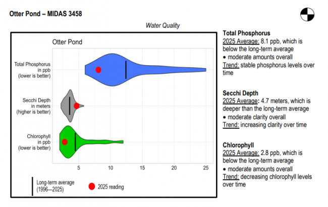
Otter Pond surface water chlorophyll (ppb), phosphorus (ppb), and Secchi depth (meters) data comparison. Colored areas represent the long-term range of values, from minimum to maximum. Area thickness indicates frequency of measurements at that value. Area thickness increases as more measurements are reported at that value. The vertical black line represents the long-term average value. The large red dot represents 2025’s average value. The small red dots represent individual readings taken in 2025.
Water Quality overview and methods
2025 as a Year (summary for all lakes)
LEA also offers technical assistance to landowners through LakeSmart evaluations and Clean Lake Check Ups.
This relatively shallow pond is homothermous with a fair amount of weedy habitat, which makes it best suited for warmwater fish management. Fisheries biologists at the Maine Department of Inland Fisheries and Wildlife introduced largemouth bass in 1958 and 1959 to enhance angling opportunities. The bass population is now self-sustaining and provides good fishing. Chain pickerel are also abundant and provide additional angling excitement. General fishing laws apply. Motorboats over 10 horsepower prohibited.
Return to LEA’s Lake Look-Up page to search for a different lake, or type it in below.
