Donate and Join LEA Today!

Sebago Lake

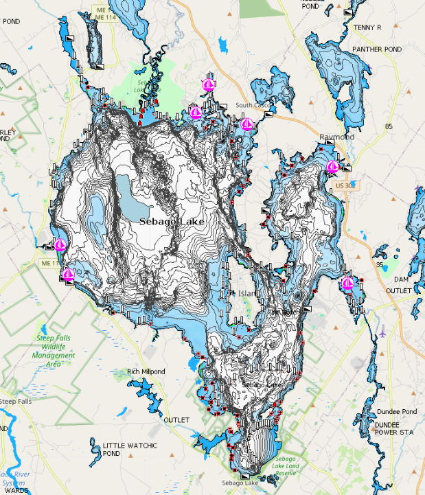
Sebago Lake is the deepest and second largest lake (after Moosehead Lake) in Maine. The lake is 12 miles long and its shoreline stretches 105 miles. It is surrounded by the towns of Casco, Naples, Raymond, Sebago, Standish and Windham. On the lake itself is the town of Frye Island. Sebago Lake is connected to Brandy Pond by the Songo River and eventually to Long Lake in Naples. The Sebago Lake watershed includes all or parts of 24 towns and covers approximately 300,000 acres. Water from this entire land area eventually reaches Sebago Lake, some directly and some indirectly (after flowing into and then out of other lakes such as Brandy Pond). Development of watershed properties in these towns as well as the approximately 4000 lots that are within 200 feet of the lake can have a substantial impact the water quality of Sebago Lake.

Fishing

The lake contains natural populations of land-locked salmon (Salmo salar sebago) and smelt because when the last major glaciers retreated, the entire watershed was under seawater, and populations of these marine animals became established as the land rose and seawaters retreated. Sebago Lake also holds a legendary place in Maine fishing lore as the home of the onetime world record (and still state-record) landlocked salmon — a 22.5-pounder caught Sept. 12, 1907, by Edward Blakeley of Darien, Conn. Another memorable Sebago salmon was caught by Jack Sharkey, a former heavyweight boxing champion who landed a 28-inch fish that weighed 10 pounds, 2 ounces on April 21, 1948. A more recent lunker was recorded on July 25, 1999, when Roger W. Kolterman hooked a salmon that weighed 8.84 pounds and was 27 inches long. Recently, however, some of the biggest fish to come out of Sebago have been Northern pike, which were introduced illegally and first documented in the lake in 2003. Northern pike were put into a number of Maine waters, fisheries biologists believe, by people trying to improve the fishing without regard to the serious consequences for native fish populations. A 17½-pound, 41-inch pike that was caught on Sebago March 16, 2010, had a 13-inch salmon in its stomach. Other game fish found in Sebago lake include lake trout, brook trout, brown trout, smallmouth bass and largemouth bass.

  • Lake Surface

    30,513 acres
  • Watershed

    440 square miles
  • Max. Depth

    316 feet
  • Elevation

    267 feet

Water Quality: 2022

Sebago Lake is the primary water supply for the Portland Water District (PWD), which serves the Greater Portland region and about 15 percent of Maine's population. It’s a fundamental fact of life that water flows down hill. That’s why PWD and LEA have a strong working partnership and share the same big goal — protecting the Sebago Lake watershed, which stretches for 361 square miles, including 71 square miles of lakes, ponds and rivers. “We’re at the bottom of the hill,” said Paul Hunt, PWD environmental manager. “And LEA is at the top of the hill. So our feeling is that every drop of water that LEA protects benefits us."

Sebago Cove is sampled by LEA once per year in August. The long-term average reflects data from 2016 to 2022. The Secchi disk reading for 2022 was 1.7 meters. The Secchi disk did hit the bottom, indicating that Secchi depth is not a reliable indicator of water clarity. The total phosphorus reading of 23.0 ppb falls into the very high range. The chlorophyll-a reading of 6.0 ppb falls into the moderate range. Long-term trend analysis indicates chlorophyll-a concentrations in Sebago Cove are stable and total phosphorus concentrations are stable. This trend analysis is based on our 6-year-long dataset and may not accurately represent long-term trends; however, trend analysis will be more precise as our dataset grows. The color reading for 2022 was 30.0 SPU, indicating that water in Sebago Cove is highly colored.

2022 Water-testing summary

Pleasant Pond’s surface water chlorophyll (ppb), phosphorus (ppb), and Secchi depth (meters) data comparison. Colored areas represent the long-term range of values, from minimum to maximum. Area thickness indicates frequency of measurements at that value. Area thickness increases as more measurements are reported at that value. The vertical black line represents the long-term average value. The large red dot represents 2022’s average value.

2022 average vs. long-term average

  • Clarity: Sebago Cove's 2022 average water clarity was within the 'low clarity' range. The Secchi disk did hit the bottom, indicating that Secchi depth is not a reliable indicator of water clarity.
  • Chlorophyll: Sebago Cove's 2022 average chlorophyll concentration was within the 'moderate' range. Sebago Cove's long-term chlorophyll trend is stable, indicating that chlorophyll concentrations are neither higher nor lower over time.
  • Phosphorous: Sebago Cove's 2022 average phosphorus concentration was within the 'high' range. Sebago Cove's long-term phosphorus trend is stable, indicating that phosphorus concentrations are neither higher nor lower over time.
    [mc4wp_form id="2536"]