


A public boat launch is located next to the town beach off of Highland Road.
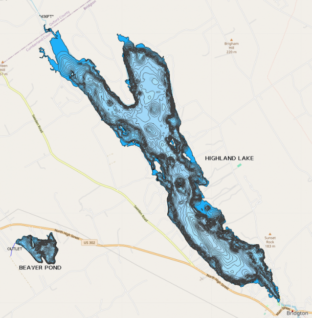
Highland Lake, originally called Crotched Pond, stretches from downtown Bridgton up to the edge of Sweden. It has over 16 miles of shoreline, two coves, and numerous islands.
Click on a program below for the most recent data summary. For descriptions of each program, return to our Lake Look-Up page.
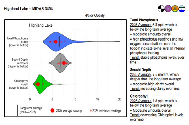
Highland Lake surface water chlorophyll (ppb), phosphorus (ppb), and Secchi depth (meters) data comparison. Colored areas represent the long-term range of values, from minimum to maximum. Area thickness indicates frequency of measurements at that value. Area thickness increases as more measurements are reported at that value. The vertical black line represents the long-term average value. The large red dot represents 2025’s average value. The small red dots represent individual readings taken in 2025.
Water Quality overview and methods
2025 as a Year (summary for all lakes)
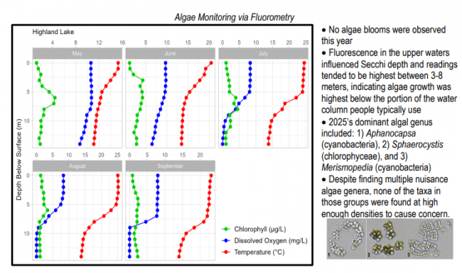
 Algae Monitoring Summary
Graphs have been included for each test site to visually compare fluorometer, temperature, and oxygen profiles from May through September. The vertical axis (y-axis) indicates depth below the surface, while the horizontal axis (x-axis) represents reported values. Three different parameters are being reported on the same graph, which results in the value units for the horizontal axis varying, based on parameter. Units are noted in parentheses in the legend.
Live Buoy Data from Highland Lake
LEA also has active Courtesy Boat Inspection and LakeSmart programs on Highland Lake and offers technical assistance to landowners through Clean Lake Check Ups.
Highland Lake is best suited to warmwater fish as the small amount of cool water present in the summer months is low in dissolved oxygen. Brown trout, however, are more tolerant of warm water than other salmonids and are heavily stocked in the lake. Other species found in the lake include smallmouth bass, largemouth bass, white perch, yellow perch, chain pickerel, hornpout, Eel, white sucker, and minnows.
General fishing laws apply, except: From October 1 – December 31: ALO (Artificial lures only), S-7 (All trout, landlocked salmon, and togue caught must be released alive at once).
A TMDL is a detailed watershed report with land use information and phosphorus loading estimates for a specific lake. TMDL stands for “Total Maximum Daily Load”. For Maine lakes, it is used as a tool to assess and reduce phosphorus loading from within the entire watershed. LEA helped compile, organize, and write a TMDL for Highland Lake with the Maine Association of Conservation Districts and the Maine Department of Environmental Protection.
The non-regulatory reports are intended to serve as a platform for future implementation work and watershed planning. It can also be used to complement comprehensive planning updates. In addition to the land use inventory and phosphorus loading estimates, the report contains water quality, fishery, and soils information, a shoreline survey, and recommendations for future best management practices in the watershed.
The completed Highland Lake TMDL can be viewed on the Maine DEP website at Highland Lake TMDL.
The primary purpose of this project was to significantly reduce erosion and export of sediment and phosphorus into Highland Lake. This multi-year grant, which ended in 2008, installed conservation practices that reduced erosion and polluted runoff at close to 40 sites throughout the watershed. Roads, residential areas, and public lands have all been addressed. Fixes included new vegetative buffer gardens, infiltration trenches, and road work designed to improve drainage and reduce wash-outs. Landowners who participated in the project received funding for up to 50 percent of the cost of the work done. The project also hosted a series of workshops to raise awareness about watershed problems and work to foster long-term watershed stewardship.
Return to LEA’s Lake Look-Up page to search for a different lake, or type it in below.
